


Jahanpanah was the fourth medieval city of Delhi established in 1326–1327 by Muhammad bin Tughlaq (1325–51), of the Delhi Sultanate. To address the constant threat of the Mongols, Tughlaq built the fortified city of Jahanpanah (meaning in Persian: “Refuge of the World”) subsuming the Adilabad fort that had been built in the 14th century and also all the establishments lying between Qila Rai Pithora and Siri Fort. Neither the city nor the fort has survived. Many reasons have been offered for such a situation. One of which is stated as the idiosyncratic rule of Mohammed bin Tughlaq when inexplicably he shifted the capital to Daulatabad in the Deccan and came back to Delhi soon after.
The ruins of the city’s walls are even now discerned in the road between Siri to Qutub Minar and also in isolated patches behind the Indian Institute of Technology (IIT), in Begumpur, Khirki Masjid near Khirki village, Satpula and many other nearby locations; at some sections, as seen at Satpula, the fort walls were large enough to have few inbuilt storerooms to stack provisions and armory. The mystery of the city’s precincts (complex) has unfolded over the years with later day excavations revealing a large number of monuments in the villages and colonies of South Delhi. Due to the compulsions of urban expansion of the Capital City of Delhi, Jahanpanah is now part of the upscale urban development of South Delhi. The village and the wealth of ruins scattered all around are now enclosed by South Delhi suburbs of Panchshil Park South, Malviya Nagar, Adchini, the Aurobindo Ashram, Delhi branch and other smaller housing colony developments. It is hemmed in the North–South direction between the Outer Ring Road and the Qutb Complex and on the east–west direction by the Mehrauli road and the Chirag Delhi road, with Indian Institute of Technology located on the other side of the Mehrauli road as an important landmark.
History
Mohammed bin Tughlaq, son of Ghiyasuddin Tughlaq who built Tughlaqabad, constructed his new city of Jahanpanah between 1326 and 1327 by encircling the earlier cities of Siri and Lal Kot with 13 gates. But what remains of the city and Adilabad fort are large ruins, which leave much ambiguity and conjectures regarding its physical status as to why and when it was built by Tughlaq. Some of the structures which have survived partially are the Bijay Mandal (that is inferred to have housed the Hazar Sutan Palace, now destroyed), Begumpur Mosque, Serai Shaji Mahal, Lal Gumbad, Baradari with other nearby structures and scattered swathes of rubble masonry walls. From Ibn Batuta’s chronicle of the period (he lived in Delhi from 1333–41) it is inferred that Lal Kot (Qutb complex) was then the urban area, Siri was the military cantonment and the remaining area consisted of his palace (Bijaymandal) and other structures like mosques, etc.
Ibn Batuta has reasoned that Muhammad Shah wished to see a unified city comprising Lal Kot, Siri, Jahanpanah and Tughlaqabad with one contiguous fortification encompassing them but cost considerations forced him to abandon the plan halfway. In his chronicle, Batuta also stated that the Hazar Sutan Palace (1000 pillared palace), built outside the Siri fort limits but within the Jahanpanah City area, was the residence of the Tughlaq.

Hazar Sutan Palace was located within the fortified area of the Jahnapanah in Bijaya Mandal (literal meaning in Hindi: ‘victory platform’). The grand palace with its audience hall of the beautifully painted wooden canopy and columns is vividly described but it does no longer exists. The Fort acted as a safe haven for the people living between Qila Rai Pithora and Siri. Tughalqabad continued to act as Tughlaq’s centre of government until, for strange and inexplicable reasons, he shifted his capital to Daulatabad, however, he returned after a short period.
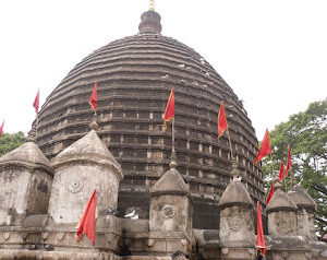
Adilabad, a fort of modest size, built on the hills to the south of Tughlaqabad was provided with protective massive ramparts on its boundary around the city of Jahanpanah. The fort was much smaller than its predecessor fort, Tughlaqabad fort, but of similar design. Archaeological Survey of India (ASI) in its evaluation of the status of the fort for conservation has recorded that two gates,
one with barbicans between two bastions on the south-east and another on the south-west. Inside, it, separated by a bailey, is a citadel consisting of walls, bastions and gates within which lay the palaces.
The fort was also known as ‘Muhammadabad’, but inferred as a latter-day development. The two gates on the southeast and southwest of Adilabad fort had chambers at the lower level while the east and west gates had grain bins and courtyards at the upper floors. The fortifications built, linking with the other two city walls, was 12 m (39.4 ft) in thickness and extended to a length of 8 km (5.0 mi). Another smaller fortress, called the Nai-ka-Kot (literally “Barber’s fortress”) was also built at a distance of about 700 m (2,296.6 ft) from Adilabad, with the citadel and army camps, which are now seen only in ruins.
Tughlaq’s primary attention to infrastructure, particularly of iron supply to the city, was also well thought out. A structure (weir or tank) with seven sluices (Hindi:Satpula, meaning “seven bridges”) was built on a stream that flowed through the city. This structure called the Satpula is still existing (though non–functional) near Khirki village on the boundary walls of Jahanpanah. Similar structures had also been built at Tughlaqabad and Delhi in Hauz Khas Complex, thus covering the water supply needs of entire population of Jahanpanah.


Reviews
There are no reviews yet